


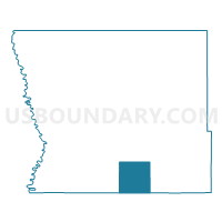
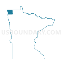
Spring Brook Twp. Voting District, Kittson County, Minnesota
About
Outline

Summary
| Unique Area Identifier | 602765 |
| Name | Spring Brook Twp. Voting District |
| County | Kittson County |
| State | Minnesota |
| Area (square miles) | 35.93 |
| Land Area (square miles) | 35.90 |
| Water Area (square miles) | 0.04 |
| % of Land Area | 99.90 |
| % of Water Area | 0.10 |
| Latitude of the Internal Point | 48.58611680 |
| Longtitude of the Internal Point | -96.70423990 |
Maps

Graphs
Select a template below for downloading or customizing gragh for Spring Brook Twp. Voting District, Kittson County, Minnesota


Neighbors
Neighoring Voting District (by Name) Neighboring Voting District on the Map
- Augsburg Twp. Voting District, Marshall County, MN
- Davis Twp. Voting District, Kittson County, MN
- Deerwood Twp. Voting District, Kittson County, MN
- Jupiter Twp. Voting District, Kittson County, MN
- Nelson Park Twp. Voting District, Marshall County, MN
- Norway Twp. Voting District, Kittson County, MN
- Sinnott Twp. Voting District, Marshall County, MN
- Tegner Twp. Voting District, Kittson County, MN
Top 10 Neighboring County Subdivision (by Population) Neighboring County Subdivision on the Map
- Deerwood township, Kittson County, MN (153)
- Nelson Park township, Marshall County, MN (125)
- Jupiter township, Kittson County, MN (111)
- Norway township, Kittson County, MN (91)
- Augsburg township, Marshall County, MN (74)
- Spring Brook township, Kittson County, MN (52)
- Tegner township, Kittson County, MN (48)
- Davis township, Kittson County, MN (30)
- Sinnott township, Marshall County, MN (24)
Top 10 Neighboring Unified School District (by Population) Neighboring Unified School District on the Map
- Tri-County School District, MN (2,116)
- Kittson Central School District, MN (2,050)
- Stephen-Argyle Central Schools, MN (1,961)
Top 10 Neighboring State Legislative District Lower Chamber (by Population) Neighboring State Legislative District Lower Chamber on the Map
Top 10 Neighboring State Legislative District Upper Chamber (by Population) Neighboring State Legislative District Upper Chamber on the Map
Top 10 Neighboring 111th Congressional District (by Population) Neighboring 111th Congressional District on the Map
Top 10 Neighboring Census Tract (by Population) Neighboring Census Tract on the Map
- Census Tract 901, Kittson County, MN (2,503)
- Census Tract 803, Marshall County, MN (2,310)
- Census Tract 902, Kittson County, MN (2,049)